A Map of our Last City
Hello again all, 30 days until e3!
This post is heavily referencing an in-game Destiny screenshot of the Last City in the recent GameInformer. Sadly I cannot post this, but you guys should check it out its a great article. This post is a continuation of this thread.
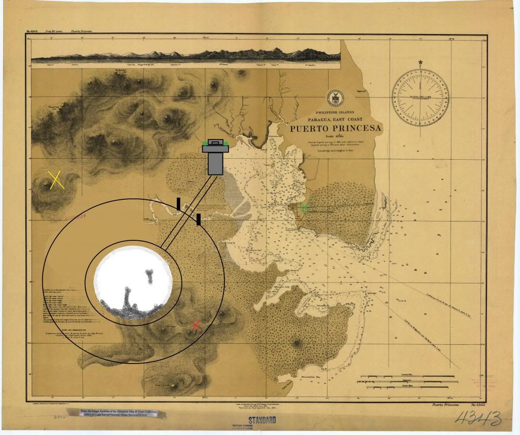
http://en.wikipedia.org/wiki/File:Puertoprincesa_chart4343_1904.jpeg
This real-life map from 1904 was found on Wikipedia after a quick search. It is a match to the background of the slides from the GDC. A compass symbol already used by Bungie can be found in the top right corner.
The following is my representation of the Last City in former Puerta Princesa, the Philippines:
http://i1275.photobucket.com/albums/y441/Adklavon/LastCityMap1_zps65264796.jpg
The Yellow X is a mountain that the sun is directly behind, and due to the high activity level of the City I assumed it to be a sunset. This would make this mountain close to West from the viewpoint's perspective.
I assumed the city would be close to the real port city from 1904 (Green X), yet i place it on the other side of the bay.
The Red X is the mountain under and left of the traveler. It is a little behind but seems to be close to the City center.
The City is shown to have 3 concentric, circular walls. The inner area, shining brightly, is most likely a sanctuary where Warlocks study and give praise. Huge buildings are seen reaching toward the surface above them. This is perhaps the safest place in the solar system. The middle ring looks to have bright, straight rows of lights, the 'suburbs'. Bright spotlights shine on the traveler. On the outside of the third ring slums have been raised, probably outside city walls but having too many people is still hopeful for humanity, right?
I believe the viewpoint is from the Tower, where Guardians preside. Just outside the City, built to watch over the cove and most likely the sprawling slum that has encompassed the City. The small towers on the outside wall might be for individual factions, or might be for defense. The main highway connects the Tower to the Traveler, and is used by what looks like many flying vehicles or trains.
So just my idea, I am open to any suggestions or comments.
Cool!
by Ragashingo ![]() , Official DBO Cryptarch, Sunday, May 12, 2013, 00:08 (4367 days ago) @ Axelrod vK
, Official DBO Cryptarch, Sunday, May 12, 2013, 00:08 (4367 days ago) @ Axelrod vK
- No text -
- No text -
A Map of our Last City
http://i1275.photobucket.com/albums/y441/Adklavon/lastcitysatmap2_zpsd02f7ab2.jpg
another take on it. I hope you all have seen the in-engine pic i'm talking about, it is jaw-dropping. They said everyone has to experience a sunset, they were not kidding.
A Map of our Last City
Interesting!
I always assumed the Tower would be close to the heart of the City, but it makes sense to put it outside, if for nothing more than that nice view!
Check out 2:26 and 3:15 of the Pathways ViDoc for a couple additional shots from what I assume is the Tower.
I also always assumed the Puerta Princesa map wasn't relevant to the world of Destiny, but rather.. just something they grabbed to use. I'm not 100% convinced that's where the City is located, but if it is, that's a cool detail.
A Map of our Last City
Thanks! Its my feeling that Bungie doesn't do too much without reason though.
In the same vidoc at around 2:35, a view of the traveler between two red flags can be seen. I'm convinced this is from the tower. The city still has 3 concentric walls, and maybe mountains behind the glow, to the left of the city?
The princess port is as good a place as any IMO.
Another possibilty
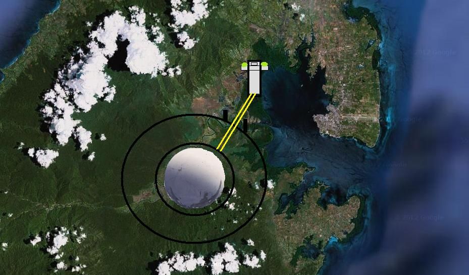
Here's what I came up with. If The City is placed in Puerta Princesa, then we might be able to take other "miscellaneous" images seriously.
With that in mind, I look at the last day of the ARG. What if that big circle actually represented The City? And then, in a classic case of seeing what I wanted to see, I was able to reference the visible mountains. I'm also assuming the water level on Earth is much higher, and that the mountain directly behind the green X isn't visible because of the current perspective.
![[image]](http://i109.photobucket.com/albums/n63/petetheduck/TheLastCity_zps97c4f37e.png)
Referencing the scale on the actual Puerta Princesa map, this would make the wall of The City about one mile in diameter. Depending how many people live outside The Wall, that puts the total population pretty low.
Good theory, one small thought
by Xenos ![]() , Shores of Time, Tuesday, May 14, 2013, 10:34 (4364 days ago) @ petetheduck
, Shores of Time, Tuesday, May 14, 2013, 10:34 (4364 days ago) @ petetheduck
Here's what I came up with. If The City is placed in Puerta Princesa, then we might be able to take other "miscellaneous" images seriously.
With that in mind, I look at the last day of the ARG. What if that big circle actually represented The City? And then, in a classic case of seeing what I wanted to see, I was able to reference the visible mountains. I'm also assuming the water level on Earth is much higher, and that the mountain directly behind the green X isn't visible because of the current perspective.
Referencing the scale on the actual Puerta Princesa map, this would make the wall of The City about one mile in diameter. Depending how many people live outside The Wall, that puts the total population pretty low.
What if the circle represents the Traveler instead? With that perspective the city could potentially be quite a bit bigger, but still give reference to where the city is, and at least a rough estimate of size.
Good theory, one small thought
Here's what I came up with. If The City is placed in Puerta Princesa, then we might be able to take other "miscellaneous" images seriously.
With that in mind, I look at the last day of the ARG. What if that big circle actually represented The City? And then, in a classic case of seeing what I wanted to see, I was able to reference the visible mountains. I'm also assuming the water level on Earth is much higher, and that the mountain directly behind the green X isn't visible because of the current perspective.
Referencing the scale on the actual Puerta Princesa map, this would make the wall of The City about one mile in diameter. Depending how many people live outside The Wall, that puts the total population pretty low.
What if the circle represents the Traveler instead? With that perspective the city could potentially be quite a bit bigger, but still give reference to where the city is, and at least a rough estimate of size.
It's possible, but then there would be several mountains within the Wall. 1 mile does seem very small.
Another possibilty
by ZackDark ![]() , Not behind you. NO! Don't look., Tuesday, May 14, 2013, 13:26 (4364 days ago) @ petetheduck
, Not behind you. NO! Don't look., Tuesday, May 14, 2013, 13:26 (4364 days ago) @ petetheduck
Nice!
One small "however": the red X mountain appears to be part of the yellow ridge in the concept art, but not anywhere near them in the chart.
A Map of our Last City
by SonofMacPhisto ![]() , Tuesday, May 14, 2013, 20:22 (4364 days ago) @ Axelrod vK
, Tuesday, May 14, 2013, 20:22 (4364 days ago) @ Axelrod vK
After reading this thread, does anyone else hope they hired Loftus to keep details straight?
I do. Always have done.
by ZackDark ![]() , Not behind you. NO! Don't look., Tuesday, May 14, 2013, 20:42 (4364 days ago) @ SonofMacPhisto
, Not behind you. NO! Don't look., Tuesday, May 14, 2013, 20:42 (4364 days ago) @ SonofMacPhisto
- No text -
A Map of our Last City
The map was already super cOLD when you made the other thread.
But your interpretation of the Game Informer screenshot is interesting.